There are 35 different multi-use nature trail networks within a 2-hour drive of the Dallas-Fort Worth metro area. The lands where these trails are located are managed by 17 different municipal, state and federal governmental entities. What is the common thread between all of these trail networks and governmental land managers? They are all built, maintained and operated by non-profit mountain bike clubs operated by citizen volunteers just like the WMBC. If you’ve biked, hiked or enjoyed an outdoor experience on a multi-use nature trail in north Texas you have non-profit, all-volunteer mountain bike associations to thank. And when you are out there riding or hiking, please remember to follow the Rules of the Trail.
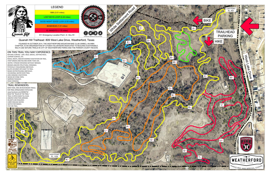
Quanah Hill is a 100-acre property managed through an agreement with the City of Weatherford and Weatherford Parks Department. Located in Parker County north of Interstate 20 and west of Lake Weatherford, the 7.1 mile trail climbs from a low elevation of 900 near the trailhead to 1040 at its highest point. The five trail names pay tribute to the people and places of Parker County. Quanah Hill has a beginner level Green Trail called Lost Boys Loop that is kid and beginner friendly. The Yellow Trail (1886), Blue Trail (Good Night, Good Luck) and Orange Trail (Bankhead Highway) are considered Intermediate level trails. The Red Trail (El Bandito) is considered an advanced level trail. MTB Project rates Quanah Hill as one of the Top 20 trails in Texas in overall satisfaction.
The Quanah Hill trailhead has parking available for approximately 45 vehicles, a bathroom and water. Trail users are asked to read the Rules of the Trail and take a photo of the trail map located on the trailhead kiosk. People on foot traverse the trail clockwise and bikers counter-clockwise.
Parking for Quanah Hill is located at 809 west Lake Drive, Weatherford, Texas (approximately 1/4 mile south of White Settlement Road).
PLEASE REFER TO THE WMBC FACEBOOK PAGE FOR TRAIL STATUS.
Click here for Quanah Hill trail details
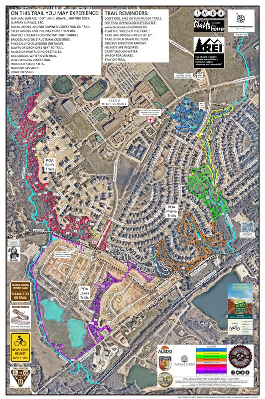
The POA Trails are now a 12+ mile, stacked loop system of 8 connected trails on a 135+ acre scenic green space inside a residential neighborhood.
The POA Trails traverse through 3 distinct environmental areas: Prairies, Bluffs and Lakes:
- South of Bailey Ranch Road the POA Prairie Trails are 5 connected trails (Blue, Yellow, Green, Orange, and Gray).
- North of Bailey Ranch Road the POA Bluffs Trail are 2 connected trails (Red and Violet).
- South of Jenkins Road the POA Lakes Trail is one trail (Purple).
Trail users are required to visit the trailhead kiosks and read the Rules of the Trails before recreating on the trails.
Emergency Medical Technician points are along all the trails. The EMT markers are noted by a red 911 trail marker in alphabetical order, letter A thru P along the POA Prairie Trails, letters AA thru RR along the POA Bluffs Trail and letters TT through ZZ along the POA Lakes Trail.
Should you require medical assistance along the trail, call 911. Give the dispatch operator your location (EMT AA, for instance). Aledo Fire/EMS has a KMZ file of the POA Trails and all EMT locations. Follow their instructions. This EMT system is in use at all WMBC trails (The Pit, Quanah Hill, and the Western Heritage Park Trail).
PARKING NOTICE: Parking is NOT allowed on Point Vista Drive.
PLEASE REFER TO THE WMBC FACEBOOK PAGE FOR TRAIL STATUS.
The POA Trails traverse through 3 distinct environmental areas: Prairies, Bluffs and Lakes:
- South of Bailey Ranch Road the POA Prairie Trails are 5 connected trails (Blue, Yellow, Green, Orange, and Gray).
- North of Bailey Ranch Road the POA Bluffs Trail are 2 connected trails (Red and Violet).
- South of Jenkins Road the POA Lakes Trail is one trail (Purple).
Trail users are required to visit the trailhead kiosks and read the Rules of the Trails before recreating on the trails.
Emergency Medical Technician points are along all the trails. The EMT markers are noted by a red 911 trail marker in alphabetical order, letter A thru P along the POA Prairie Trails, letters AA thru RR along the POA Bluffs Trail and letters TT through ZZ along the POA Lakes Trail.
Should you require medical assistance along the trail, call 911. Give the dispatch operator your location (EMT AA, for instance). Aledo Fire/EMS has a KMZ file of the POA Trails and all EMT locations. Follow their instructions. This EMT system is in use at all WMBC trails (The Pit, Quanah Hill, and the Western Heritage Park Trail).
PARKING NOTICE: Parking is NOT allowed on Point Vista Drive.
- Primary Trailhead Parking is at 1700 Jenkins Road (just west of Bailey Ranch Road). See trail map for location.
- Overflow parking for the Jenkins Road Trailhead is along Bailey Ranch Road. (Please do not park inside the Bailey Ranch Road round-a-bout)
- On Saturday and Sunday ONLY: Trail users may park at the First Aledo Bank (900 Bailey Ranch Road). See trail map for location.
PLEASE REFER TO THE WMBC FACEBOOK PAGE FOR TRAIL STATUS.
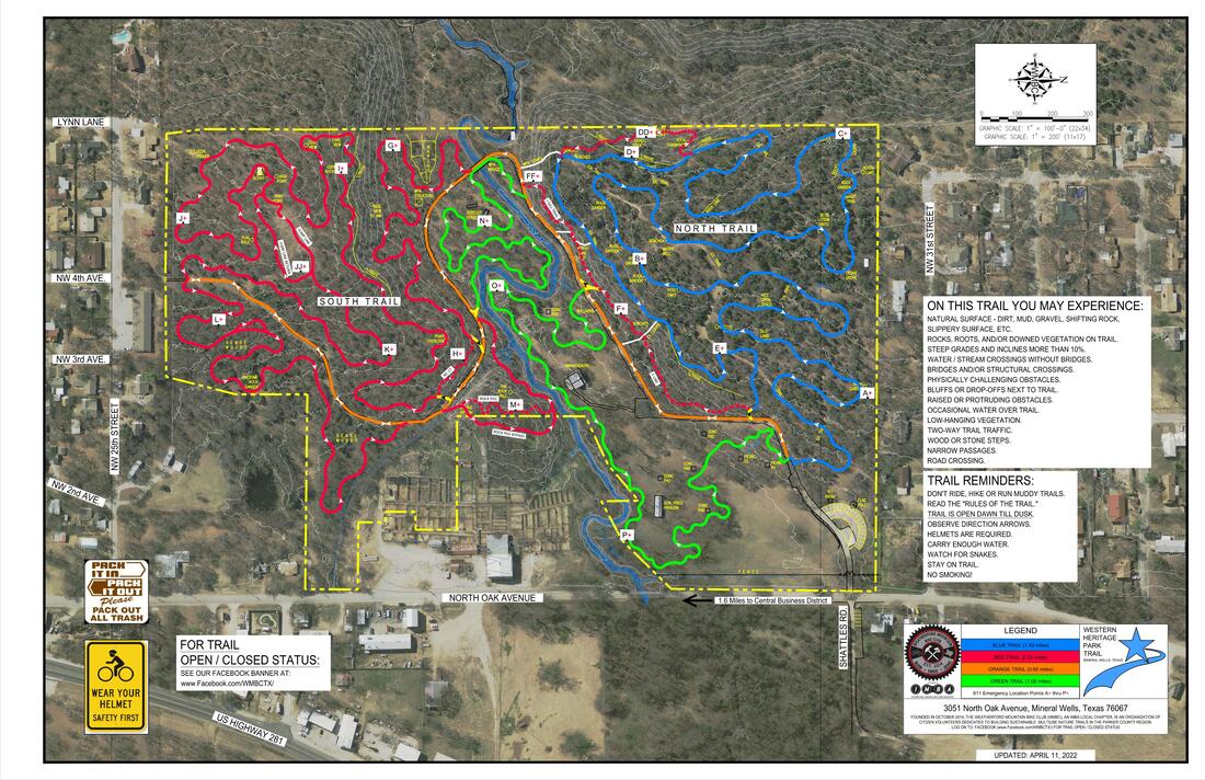
The WHP Trail is an approximately 4.35-mile loop consisting of 4 primary trails (Orange, Green, Blue and Red). There is a two-way roadway/trail (Orange) that bisects the park. Additionally, there are bypass trails (Yellow) to divert bikers from and to the more difficult trails.
The Western Heritage Park Trail (WHP Trail) is located at 3051 North Oak Avenue (approximately 1.6 miles north of downtown). There is parking available for approximately 20-25 vehicles. If the parking area is full you may park in the overflow parking on Shattles Road (which is directly across the street from the park entrance). Parking on Shattles Road is in the grass on the north side of the road. Please do not block Shattles Road as it does serve residences. The trailhead kiosk is adjacent to and west of the park parking area. Please read the Rules of the Trail and Trail Map on the kiosk. It is a good idea to take a photo of the trail map until you become familiar with the routes.
The goal of the Western Heritage Park Trail is to bring mountain biking to a new community. The terrain of Palo Pinto County is unlike what many riders experience in the DFW area. We hope that the mountain bike community will embrace the technically challenging trails of Western Heritage Park Trails, grow confidence in riding them and above all, have fun.
PLEASE REFER TO THE WMBC FACEBOOK PAGE FOR TRAIL STATUS.
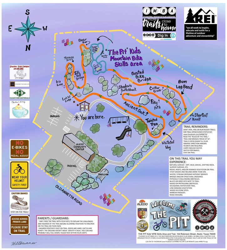
The Pit is a kids Mountain Bike Skills area and trail located at 104 Robinson Street in downtown Aledo. It consists of small rollers, berms, rock gardens and bridges suitable for kids and beginners and includes an 1,800 linear foot singletrack trail that meanders around the community center property and nearby creek. The Pit was entirely built with volunteer effort and cooperation with area businesses and citizens that provided services, materials, and funding. The Aledo Community Center has plenty of parking, a fantastic playground, a pavilion, nearby restaurants, coffee shops and stores.
Other Regional Trails
There are many other trails to be explored in the Dallas / Fort Worth region. Check out the websites of our DFW mountain bike partners for guides and information on trails and events:
Dallas Off Road Bicycle Association (DORBA)
Fort Worth Mountain Bikers Association (FWMBA)
Dallas Off Road Bicycle Association (DORBA)
Fort Worth Mountain Bikers Association (FWMBA)